You come to Saba to do one thing: hike. And hike you shall. I spent a week diving deep into the Saba hiking scene
This tiny island in the Dutch Caribbean doesn’t have beaches or tourist resorts — but what it does have is some of the most underrated hiking in the Caribbean. Known as “The Unspoiled Queen,” Saba is packed with lush rainforests, steep mountain trails, and a trail network that rivals anywhere else in the region.
During my week on the island, explored the Saba hiking scene — covering every major trail (some of them twice) and often hiking without seeing a single other person. If you’re looking for something quieter, greener, and more adventurous than your average tropical getaway, this guide to hiking in Saba has you covered.
Let’s get into the best trails and real tips from someone who’s walked them all.
Find where to stay in Saba at the best hotels and villas on Expedia!
Table of Contents
Overview of Hiking in Saba
Why Saba is a Hidden Gem for Hikers
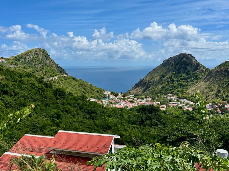
Most travelers have never even heard of Saba — and that’s exactly what makes it such a special hiking destination. This steep, volcanic island rises dramatically out of the sea and is crisscrossed by jungle trails, ridge walks, and cloud forest paths. With no beaches or crowds, Saba hiking is all about nature, solitude, and exploring on foot.
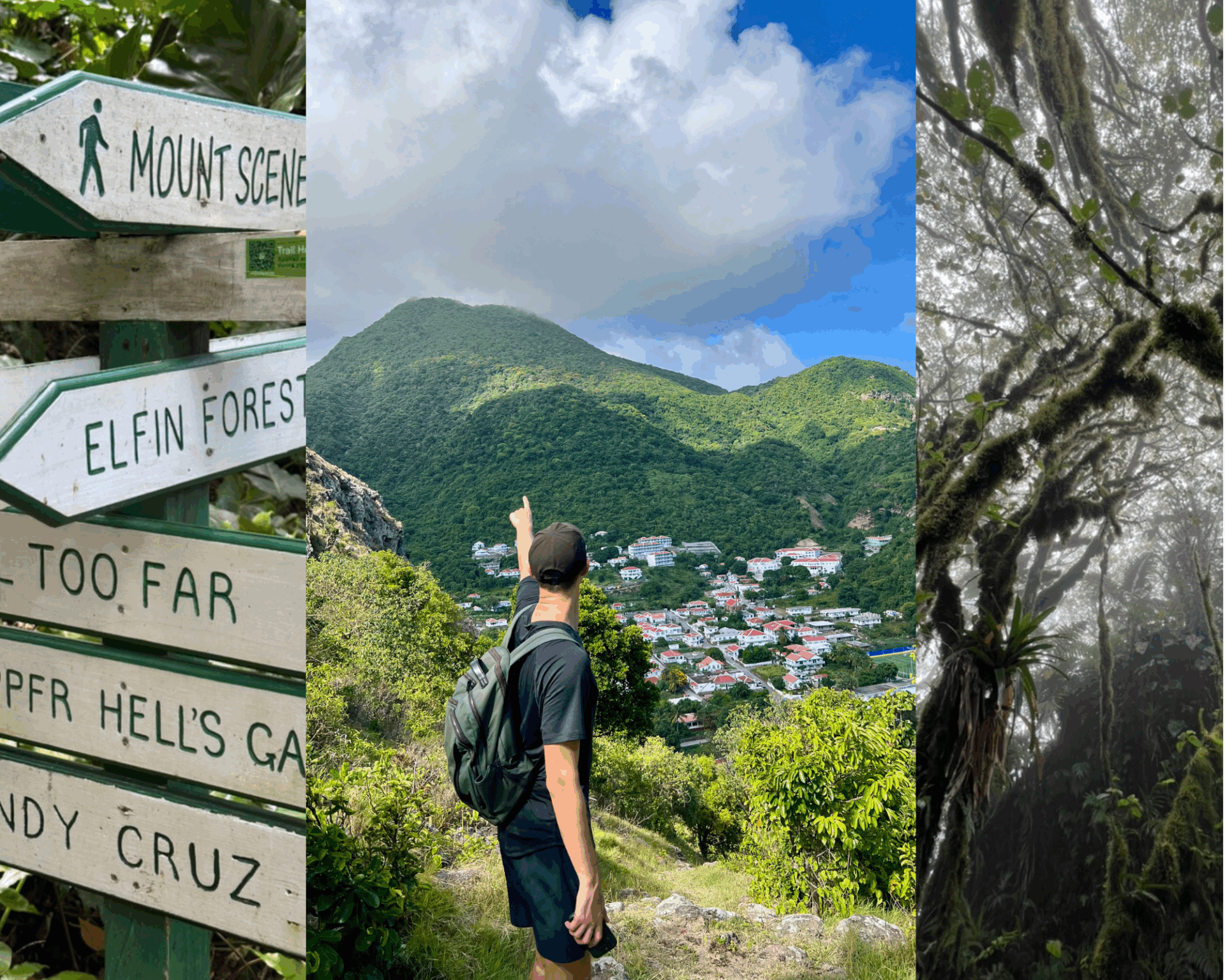
Outside of the Mount Scenery Trail, I rarely saw anyone else on the trails — even in July. If your idea of a Caribbean adventure involves trekking through misty forests instead of lounging poolside, hiking in Saba is for you.
Trail Quality, Markings, and Access Points
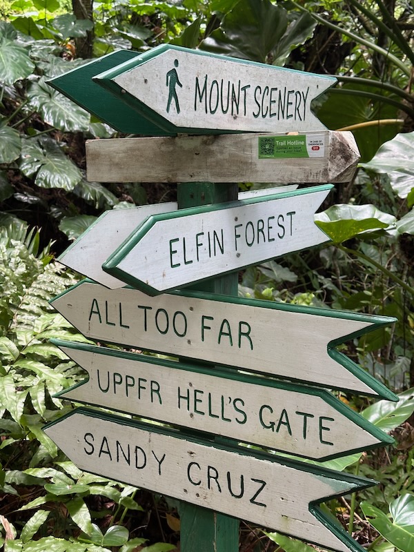
One of the best things about the Saba hiking network is how well-organized it is. Trails are clearly marked with signs and blazes, and many routes connect to each other so you can create your own loops. Most trailheads are easily accessible from the main villages — Windwardside, Hell’s Gate, or The Bottom.
While some trails are paved or stepped, others are rugged and muddy, especially after rain. But overall, the hiking in Saba experience is far better maintained than you might expect for such a small island.
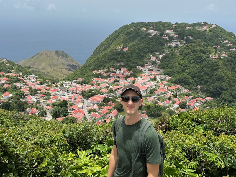
Mount Scenery Trail
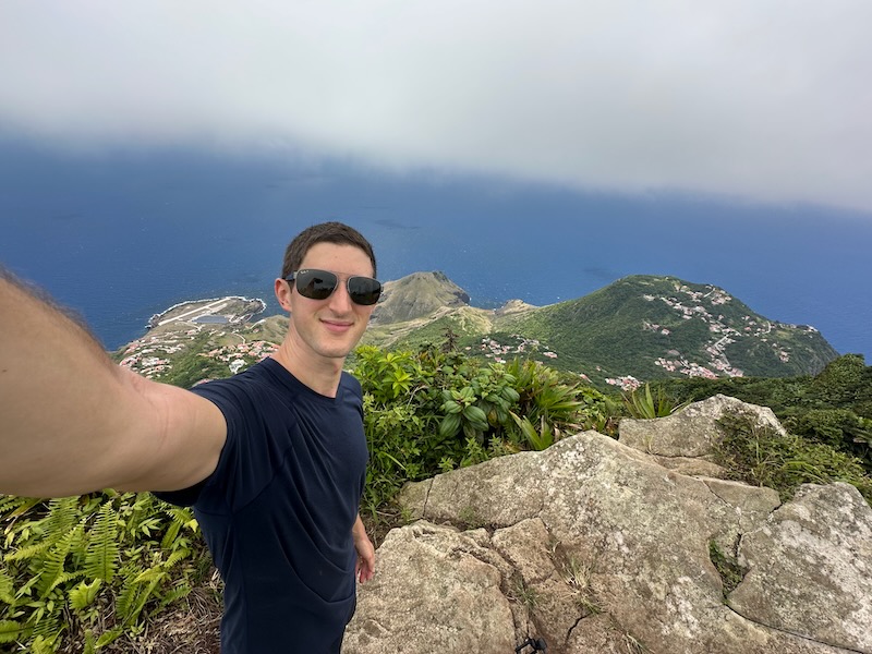
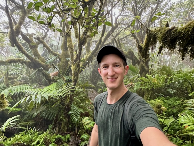
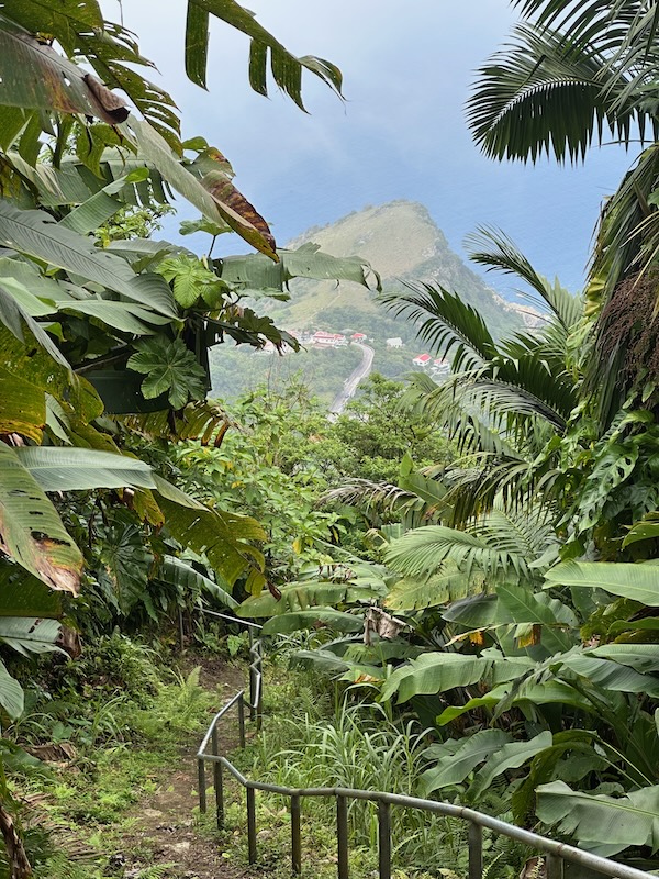
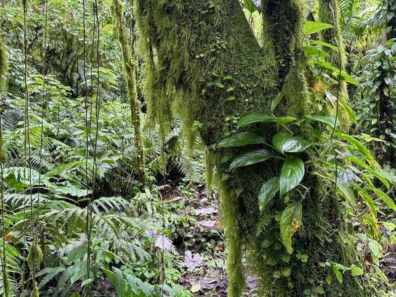
The Mount Scenery Trail is the crown jewel of Saba hiking — and for good reason. This steep but rewarding trail takes you through thick rainforest, mossy cloud forest, and up to the highest point in the entire Kingdom of the Netherlands. At 877 meters (2,877 feet), the summit offers sweeping views on a clear day and moody, mist-draped beauty when clouds roll through.
Learn more about the Mount Scenery Trail with my complete trail guide!
This is the most popular route for hiking in Saba, but even in peak season, you won’t see more than a few people. I did this trail multiple times during my week on the island, and every hike felt a little different depending on the weather. It’s short, steep, and totally worth it.
Trail Info:
- Distance: ~2.1 km one way (4.2 km roundtrip)
- Difficulty: Moderate to strenuous (stairs, elevation)
- Starting Point: Windwardside (opposite the Trail Shop)
- Time: 1.5 to 2.5 hours roundtrip
- Highlights: Cloud forest, panoramic views, misty jungle
- Pro Tip: Go early for clearer skies and cooler temps
Sandy Cruz Trail
If you want a quieter Saba hiking experience, the Sandy Cruz Trail is a great choice. This trail runs along the remote north side of the island, far from the villages and roads. It’s one of the flattest trails on Saba, making it a good option for those looking for something a bit more relaxed without sacrificing that feeling of wilderness.
While you won’t find dramatic viewpoints here, the shaded forest, peaceful vibes, and total solitude make it worth your time — especially if you’re aiming to explore the full hiking in Saba network.
Trail Info:
- Distance: ~3.5 km one way
- Difficulty: Easy to moderate
- Starting Points: Upper Hell’s Gate or connect via Elfin Trail
- Time: ~1.5 to 2 hours one way
- Highlights: Quiet jungle, ridge walking, remote terrain
- Pro Tip: Use this as part of a full loop around the island
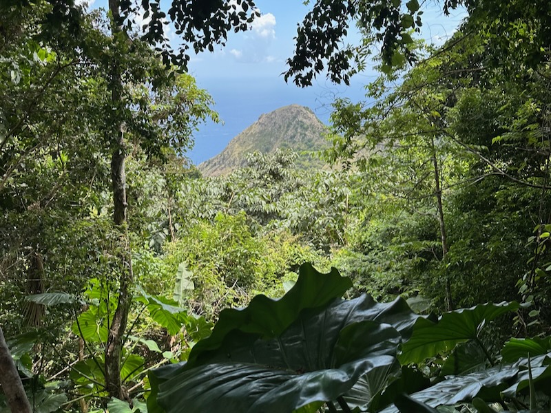
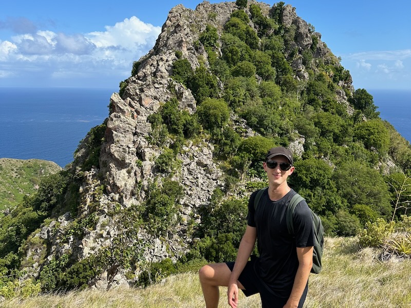
Elfin Trail
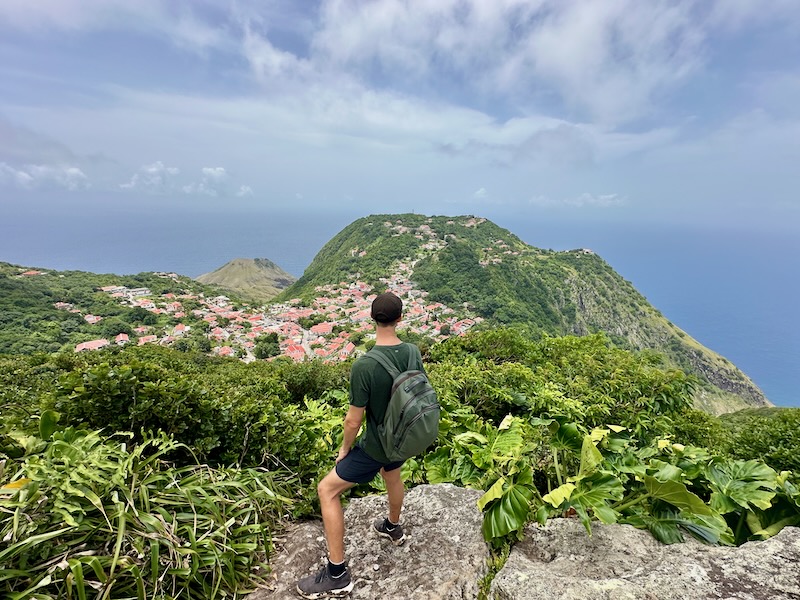
One of the most rugged and rewarding routes in the Saba hiking scene, the Elfin Trail winds through a remote section of cloud forest and connects the Mount Scenery and Sandy Cruz trails. I started from Mount Scenery and descended toward Sandy Cruz — which I highly recommend to keep it mostly downhill.
This is a rougher trail, especially after rain, but it’s full of character: mossy trees, slick roots, and even a viewpoint bench overlooking the famous Saba airport. This is hiking in Saba at its most wild and untouched.
Trail Info:
- Distance: ~2.5 km
- Difficulty: Moderate, with muddy sections
- Starting Point: Links Mount Scenery to Sandy Cruz
- Time: ~1 to 1.5 hours
- Highlights: Cloud forest, airport views, solitude
- Pro Tip: Watch your footing — it gets slippery in spots
Mas Cahones Trail
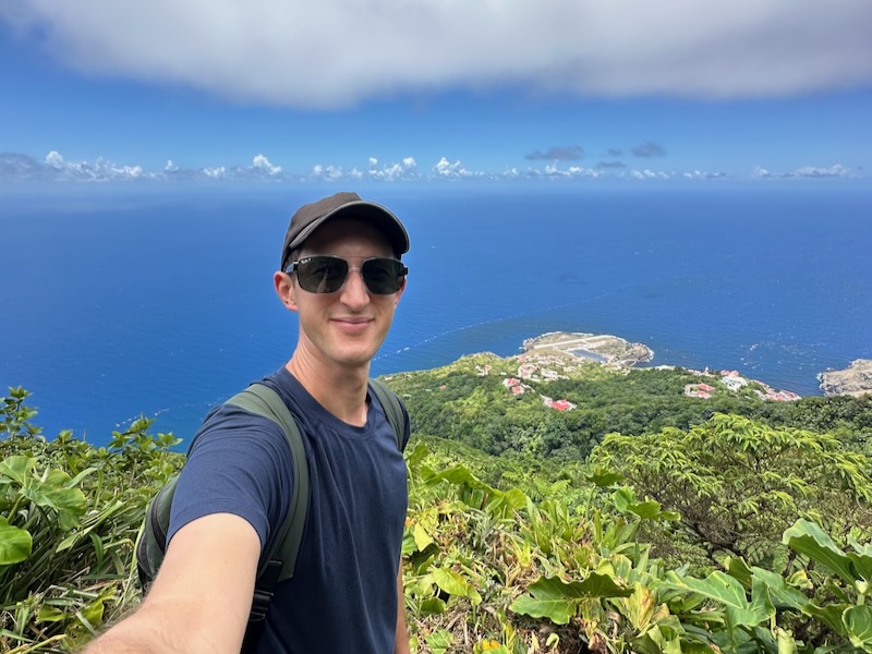
Short on time but still want a taste of hiking in Saba? The Mas Cahones Trail is a quick detour with a big payoff. Branching off from the Mount Scenery Trail, it takes about 20 minutes to reach one of the best viewpoints on the island.
From the top, you’ll see the rooftops of Windwardside, the hills around Booby Hill, and the coastline below. It’s an easy add-on if you’re already doing Mount Scenery — or a great mini-hike if you’re easing into the Saba hiking trail system.
Trail Info:
- Distance: ~1 km roundtrip
- Difficulty: Easy
- Starting Point: Off Mount Scenery Trail, near Windwardside
- Time: ~20–30 minutes
- Highlights: Big views with little effort
- Pro Tip: Go on a clear morning for the best photo ops
Bottom Mountain Trail
The Bottom Mountain Trail connects the village of Windwardside to The Bottom and is often included in longer Saba hiking loops. While it’s less scenic than other trails, it takes you through lush interior forest and is a good option if you’re linking routes.
This trail is a bit more rugged, with ropes to help on steep sections and some uneven footing. There aren’t many big view points here, but if you’re all in on hiking in Saba and want to see the full island, it’s worth adding to your itinerary. Just know that the reward here is more about the experience than the scenery.
Trail Info:
- Distance: ~2.5 km
- Difficulty: Moderate to strenuous
- Starting Point: Between The Bottom and Windwardside
- Time: ~1.5 hours
- Highlights: Dense forest, connection between towns
- Pro Tip: Best used as part of a full island hiking route
Crispeen Track
The Crispeen Track is one of the more modest trails in the Saba hiking network, but it still plays an important role — especially if you’re piecing together longer routes across the island. It runs along the mid-elevation zone between Windwardside and The Bottom, often serving as a connecting trail between more scenic routes like the Elfin Trail and Bottom Mountain Trail.
On its own, the Crispeen Track isn’t the most exciting hike in Saba. There aren’t many viewpoints, but you’ll pass through some beautiful native vegetation and likely spot a few birds if you’re into birdwatching. Think of it as more of a practical part of your overall Saba hiking experience — not a destination hike, but a link in the chain.
Trail Info:
- Distance: ~2 km
- Difficulty: Easy to moderate
- Starting Point: Between Windwardside and The Bottom
- Time: ~45 minutes to 1 hour
- Highlights: Forest path, birdwatching, trail connector
- Pro Tip: Use it to complete a full island loop or get between villages on foot
Parish Hill Trail
The Parish Hill Trail is short, steep, and well worth the climb. Unlike most other Saba hiking trails, this one doesn’t connect to the main trail system — but it’s a great standalone hike if you’re staying in The Bottom. You’ll ascend quickly through thick greenery before reaching a summit that gives you panoramic views over The Bottom and up toward Mount Scenery.
It’s a great option if you want a quick workout with a nice payoff — or just want to see another perspective of Saba’s dramatic terrain. I did this one as an early morning hike, and it was totally worth the sweat.
Trail Info:
- Distance: ~1 km roundtrip
- Difficulty: Moderate (steep but short)
- Starting Point: The Bottom
- Time: ~30–45 minutes
- Highlights: Overlook of The Bottom, mountain views
- Pro Tip: Combine with a walk around town or save for a short sunrise hike
Tips for Hiking in Saba
Whether you’re tackling Mount Scenery or connecting trails for a full island loop, these tips will help you make the most of your Saba hiking experience:
- Bring plenty of water. Most trails involve a lot of elevation gain, and there’s nowhere to refill once you’re out there.
- Pack snacks or lunch. There are no food vendors or rest stops along any trail, so come prepared — especially for longer routes.
- Expect to sweat — a lot. Between the tropical climate and constant ups and downs, hiking in Saba is a full-body workout. Lightweight, breathable clothing helps.
- Wear sturdy hiking shoes or trail runners. Many trails are slick, muddy, or uneven, especially after it rains.
- Download offline maps. AllTrails and Google Maps (offline mode) both work well for navigating the Saba hiking network.
- Carry a basic first aid kit. Slippery paths, sharp roots, and rope sections mean it’s good to have basics like band-aids and antiseptic.
- Check the weather before you go. Rain can turn trails muddy and cloud up the views, especially on Mount Scenery.
- Use a hiking pole if you have one. Especially useful for the steeper or muddier sections.
- Pick up a paper trail map in Windwardside. Available at the Trail Shop — they also offer local tips and a souvenir certificate if you summit Mount Scenery.
- Start early in the day. It’s cooler, and you’ll have a better shot at clear views before clouds move in.
- Watch for wildlife. Keep an eye out for native birds, hermit crabs, and Saba’s lush, protected flora along the trails.
- Respect the environment. Leave no trace — Saba takes pride in its nickname as “The Unspoiled Queen”, and the hiking trails reflect that.
- You don’t need a guide for most trails. The trail network is well-marked and easy to follow, though guided hikes are available if you want deeper insight into local ecology.
- Best time of year to hike in Saba: November to April offers cooler, drier conditions, but even in summer, the altitude keeps things surprisingly comfortable.
Where to Stay in Saba for Hiking
Since hiking in Saba is the island’s main attraction, where you stay can really shape your experience. The island’s three main villages — Windwardside, The Bottom, and Hell’s Gate — are all small and scenic, but each has its pros and cons depending on what kind of hiking trip you’re after.
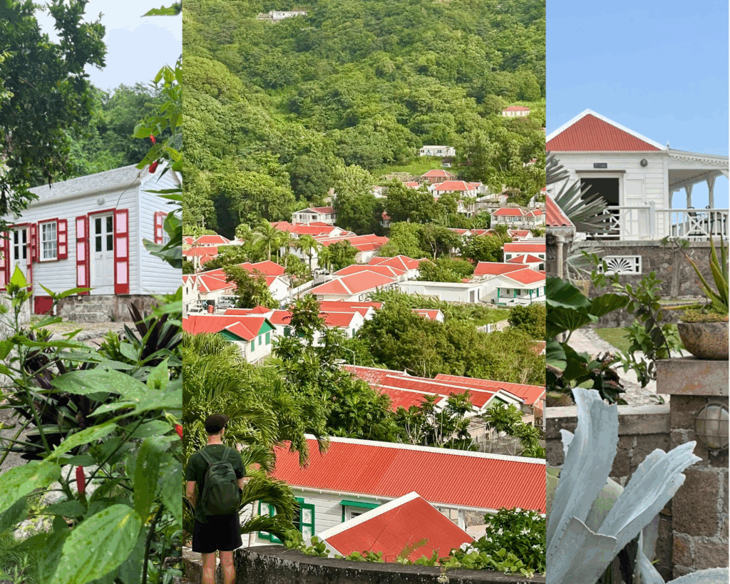
Windwardside (Best for Access to Trails)
If you’re planning a Saba hiking trip, Windwardside is hands-down the best place to stay. Most trailheads — including Mount Scenery, Mas Cahones, Elfin Trail, and Crispeen Track — are within walking distance. You’re also close to the Trail Shop, where you can pick up maps, chat with locals, or grab that souvenir certificate after summiting the peak.
Windwardside has the most options for food, gear, and casual cafés on the island — though “busy” here still means incredibly peaceful.
Places I recommend staying:
- Spyglass Villa – A stunning private villa with some of the best views on the island. Great for couples or groups.
- House on the Path – Tucked into the hillside with direct access to the trails. Perfect for hikers who want to roll straight out the door and into the jungle.
- The Cottage Club Hotel– Quirky and charming with rustic Caribbean cottages set around a hillside garden.
- Juliana’s Hotel – A laid-back, centrally located option with a great restaurant and friendly vibe. Ideal if you want comfort and easy access to everything.
Recommended for: Easy trail access, mountain views, best home base for hikers
Good to know: This is the “main” village, but still super quiet — don’t expect nightlife, just nature and good vibes
Learn more about where to stay in Saba with this guide!
Alternative: The Bottom or Zion’s Hill (Limited Access & Fewer Stays)
If you’re looking for a quieter stay away from Windwardside, The Bottom or Zion’s Hill (also known as Hell’s Gate)can work — but just know that options for accommodations and food are limited, and you’ll be further from most trailheads.
The Bottom is the island’s capital and has a more local, residential vibe. It’s walkable to Parish Hill, Bottom Mountain Trail, and Crispeen Track. Zion’s Hill, meanwhile, sits near the start of the Sandy Cruz Trail and offers beautiful views — but there are very few places to stay there.
These spots are peaceful and scenic, but they’re better suited for travelers who don’t mind extra walking or have a rental car.
Recommended for: Seclusion, slower pace, local feel
Good to know: Limited dining and lodging, and longer walks to most Saba hiking trails
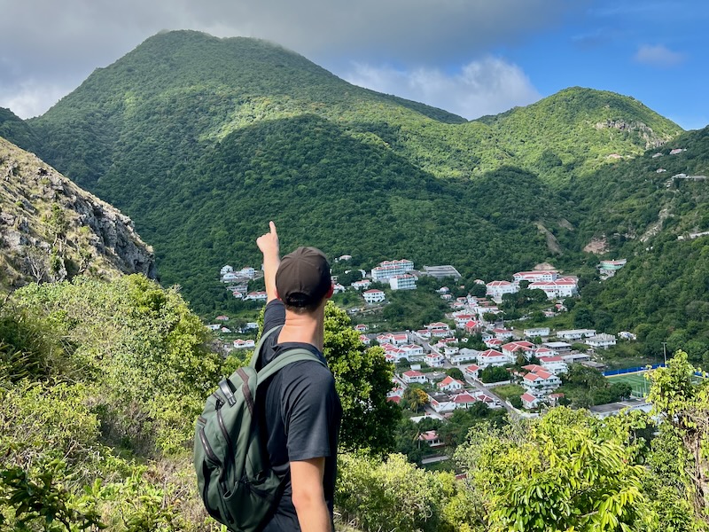
Conclusion – Is Hiking in Saba as Good as They Say?
Absolutely — and maybe even better.
What makes Saba hiking special isn’t just the dramatic terrain or the misty cloud forests. It’s the solitude. I’ve hiked all over the world, and I’ve never experienced trails this beautiful with so few people on them. Aside from Mount Scenery, I was completely alone on every trail — even in July.
If you only have time for one hike in Saba, Mount Scenery and the Elfin Trail give you a true taste of what the island has to offer. But if you love hiking, I highly recommend doing the full loop or spending a few days exploring trail by trail. The network is well-marked, diverse, and easy to piece together.
Whether you’re a casual hiker or a seasoned trekker, hiking in Saba will surprise you — and stay with you long after you leave.
F.A.Q.’s about Saba Hiking
What are the best hiking trails in Saba?
The best hikes in Saba include the Mount Scenery Trail, Elfin Trail, Sandy Cruz Trail, and Mas Cahones Trail. Each offers a unique view of Saba’s lush landscape.
Is hiking in Saba safe for beginners?
Yes, hiking in Saba is generally safe for beginners. Trails like Sandy Cruz and Crispeen Track are less strenuous, while Mount Scenery and Elfin Trail are better for moderate-level hikers.
Do I need a guide to hike in Saba?
You don’t need a guide for most trails. The Saba hiking network is well-marked, but local guides are available if you want more insight into the island’s nature and history.
How long are the hiking trails on Saba?
Trail lengths vary from short 30-minute hikes (like Mas Cahones or Parish Hill) to multi-hour loops that connect several trails. Most range between 1 to 3.5 km.
Can you hike between towns in Saba?
Yes! Trails like the Bottom Mountain Trail and Crispeen Track connect the villages of Windwardside, The Bottom, and Hell’s Gate.
Where do I get a Saba trail map?
You can pick up a paper trail map at the Trail Shop in Windwardside. They also have local advice and hiking certificates for reaching Mount Scenery.
Are the trails in Saba well-marked?
Yes. Most Saba hiking trails are clearly marked with signs and colored trail blazes. Maps and GPS apps are still useful, especially for longer loops.
What’s the best time to hike in Saba?
The best time to hike in Saba is from November to April when it’s cooler and drier, but hiking is possible year-round thanks to the island’s mild mountain climate.
What gear do I need to hike in Saba?
Lightweight hiking clothes, sturdy shoes, plenty of water, and offline maps are essential for hiking in Saba. A hiking pole and rain gear are helpful, too.